DJI Terra 5.3.0 Adds Thermal Mapping, AI Assistant and 3D Tools

DJI Terra 5.3.0, released on July 23, 2026, can turn thermal drone images into a full 2D temperature map. The update also adds 3D reconstruction from recorded video, rolling-shutter correction, cluster processing for Gaussian Splatting, local elevation files and a built-in AI assistant. DJI published a detailed feature overview on July 31.
It is aimed at surveyors, thermal-inspection teams, emergency responders, utilities, solar operators and companies building large 3D models from drone data. It is a Windows release, available through DJI Enterprise, and which features you get can depend on your Terra edition, license, hardware and drone or payload.
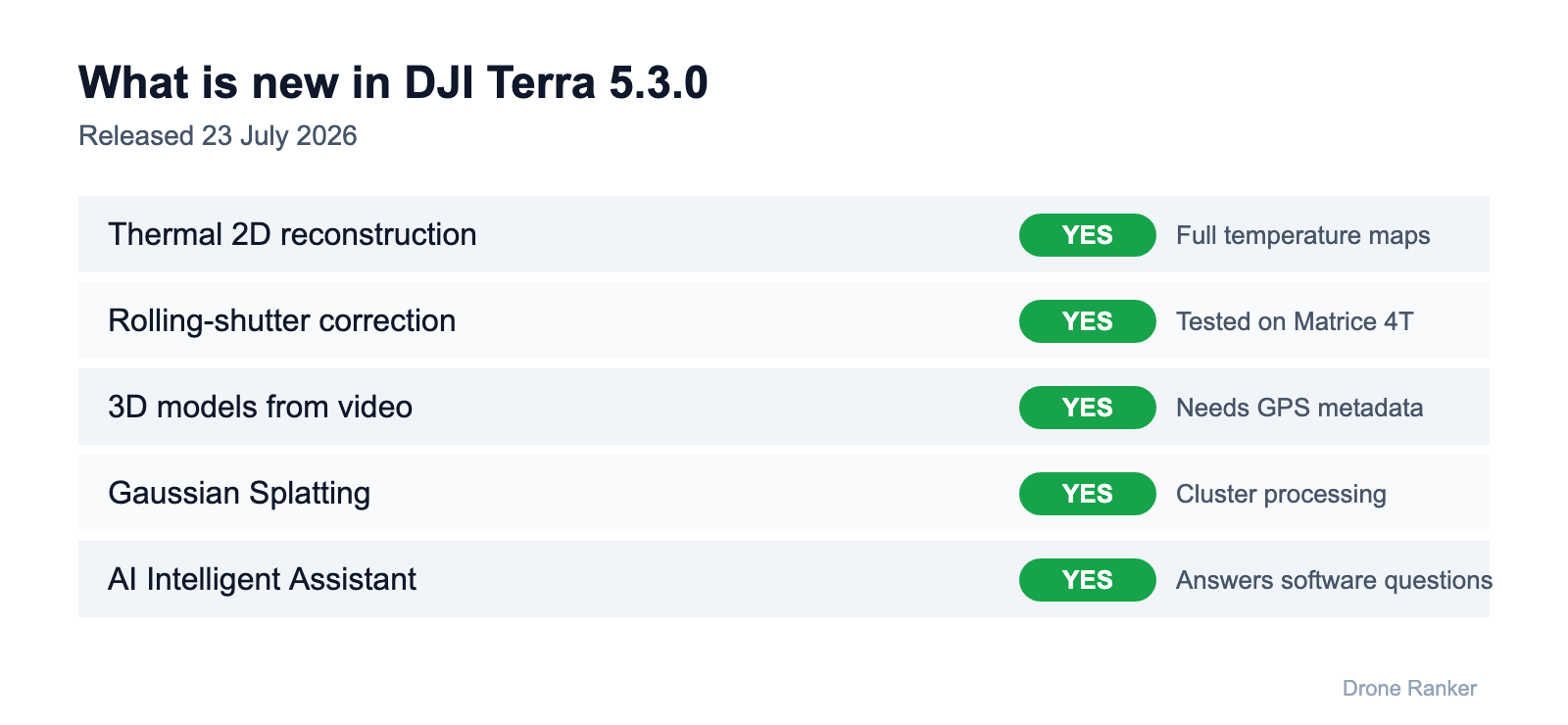
Table of Contents
DJI Terra thermal images become complete 2D maps
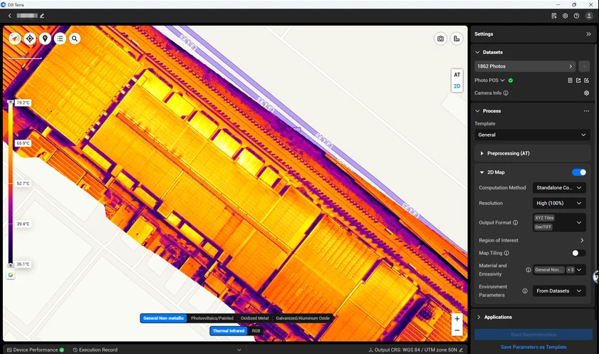
Thermal 2D Reconstruction is the headline, and in my view the most useful change. Thermal inspections have often meant going through individual infrared photos. Terra can now combine visible-light and thermal images from the same mission into one 2D thermal map that carries temperature data, so a team can document anomalies across a whole site instead of in disconnected frames.
You can measure temperature at points, along lines or across selected areas, choose from ten thermal color palettes, and export temperature reports as PDF or XLSX. That suits solar arrays, electrical and utility networks, industrial equipment, buildings and roofs, and public-safety incidents.
DJI lists support for the Mavic 3T, Matrice 3TD, Matrice 4T, Matrice 4TD, Zenmuse H20N, H20T and H30T. Visible-light photos are still required for aerial triangulation, so this is not built to work from infrared images shot in darkness alone. DJI’s newest enterprise hardware, the Dock 4 and Matrice 5TD, arrived in October.
Rolling-shutter correction
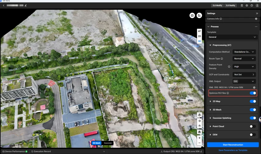
Rolling-shutter sensors can produce geometric distortion, the “jello effect”, when a drone moves fast. Terra 5.3.0 adds high-precision reconstruction that tries to correct this before aerial triangulation, mapping or 3D reconstruction, and rolling-shutter and global-shutter images can now share a dataset.
DJI says it tested the feature with the Matrice 4T at 60 and 120 meters and reported horizontal accuracy of roughly three to four times the ground sampling distance (GSD) and vertical accuracy of roughly four to five times GSD, with stable RTK positioning. Drone Ranker has not verified those figures. DJI still recommends a global-shutter mapping drone such as the Matrice 4E for strict survey-grade work.
3D models from recorded video
With video frame extraction, you import a recording, pick the time range, and Terra pulls suitable frames for reconstruction. That helps when an emergency team shot video instead of photos, when an earlier flight has usable footage, or when there was no time for a structured mapping mission after an incident.
The video must carry GPS metadata, and DJI recommends its enterprise platforms for capture. It won’t replace a properly planned photogrammetry mission, but it is a way to recover mapping data from footage you already have.
Cluster processing for Gaussian Splatting
3D Gaussian Splatting (3DGS) builds highly detailed, realistic 3D scenes from photos or LiDAR point clouds. Terra can now spread that work across several networked computers, as well as run it on local multi-core machines. Output goes to TerraGS, PLY or 3D Tiles, and Terra can produce a Digital Orthophoto Map alongside it. Each processing node needs its own Gaussian Splatting license.
DJI Terra AI assistant and smaller changes
The new AI Intelligent Assistant answers software questions and gives operating guidance inside Terra; it needs an internet connection. An execution-record panel now shows processing stages, results, error codes and troubleshooting information, which should cut time spent in manuals or diagnosing failed jobs.
Other additions:
- online documentation and automatic update notifications
- one-click cache cleanup
- LAS 1.4 and LAZ 1.4 point-cloud exports
- fewer artifacts around water, buildings and sky
- local GeoTIFF elevation-file support
- new regional coordinate and reporting options
The update is most relevant to teams flying the Matrice 4T for thermal inspection or the Matrice 4E for mapping. For solar, utility, public-safety and survey teams, it could mean fewer handoffs between separate processing tools.
Enterprise drones listed on Amazon US
Mapping-focused enterprise drone listed on Amazon US.
DJI Matrice 4TD
Thermal, wide and tele cameras; the dock-ready Matrice 4 variant, with RC Plus 2 Enterprise.
As an Amazon Associate, Drone Ranker earns from qualifying purchases. We do not quote prices because Amazon’s change by the hour.
Based on DJI Enterprise’s Terra feature announcement, software download page and version 5.3.0 release information. Last verified August 3, 2026.
The Friday Brief
One email a week on what changed in drones
FCC and FAA rule changes, DJI leaks checked against filings, and the week’s new comparisons. Every Friday, nothing else.
Free. Unsubscribe in one click. Sent with Kit; see our privacy policy.
Follow us on Google too: add Drone Ranker as a preferred source →
Continue Reading
All News